
State Maps with Regional Councils and Alternatives
by Census Regions and Divisions - Part 2
6. East North Central Division -Midwest Region
27. Michigan

Michigan Association of Regions
http://www.miregions.org/about.html
28. Ohio

Ohio Association of Regional Councils
http://regionalcouncils.org/members

Greater regional pattern can be seen with Ohio Area Agencies on Aging
http://www.aaa11.org/findaaa.asp
29. Indiana

Indiana Association of Regional Councils
http://www.iarc.cc/members/council-directory/

Indiana MPO Council – MPOs fill center – data regions can be used for balance
30. Illinois

Illinois Association of Regional Councils

Greater regional pattern can be seen with Illinois DOT Regions and Distiricts
http://www.dot.state.il.us/idotmap.html
31. Wisconsin

Association of Wisconsin Regional Planning Commissions (AWRPC)
Wisconsin Department of Commerce - Regional Planning Commissions
http://www.commerce.state.wi.us/bd/BD-RPC-map.html
7. West North Central Division -Midwest Region
32. Minnesota

1 Northwest Regional Development Commission
2 Headwater Regional Development Commission
3 Arrowhead Regional Development Commission
4 West Central Initiative
5 Development Commission
6 E Mid-Minnesota Regional Development Commission
6W Upper Minnesota Valley Regional Development Commission
7E East Central Regional Development Commission
7W Economic Development Region 7W
8 Southwest Regional Development Commission
9 Development Commission
10 Southeast Economic Development & Planning Region 10 - no organization
11 Metropolitan Council
Map at Minnesota Department of Transportation - Transportation Planning Partners
Minnesota Metropolitan and Regional Planning Organizations
www.dot.state.mn.us/planning/program/MPORDC.html
Minnesota Regional Development Commissions
33. North Dakota

North Dakota Department of Commerce Regional Councils
1 Tri County Regional Development Association
2 Souris Basin Planning Council
3 North Central Planning Council
4 Red River Regional Council
5 Lake Agassiz Regional Council
6 South Central Dakota Regional Council
7 Lewis and Clark Regional Development Council
8 Roosevelt-Custer Regional Council
http://www.communityservices.nd.gov/community/block-grant/regional-council/
34. South Dakota

South Dakota Department of Environment & Natural Resources - listing and map link
http://denr.sd.gov/dfta/wwf/techassistance.aspx#Planning

South Dakota's nine tribal governments
http://www.sdtribalrelations.com/tribes.asp
35. Iowa

Area 15 Regional Planning Commission
Bi-State Regional Commission - BSRC
Chariton Valley Planning and Development Commission
East Central Intergovernmental Association - ECIA
East Central Iowa Council of Governments - ECICOG
Iowa Northland Regional Council of Governments - INRCOG
Metropolitan Area Planning Agency - MAPA
MIDAS Council of Governments
North Iowa Area Council of Governments - NIACOG
Northwest Iowa Planning and Development Commission - NWIPDC
Region 6 Planning Commission
Region XII Council of Governments
Siouxland Interstate Metropolitan Planning Council - SIMPCO
Southeast Iowa Regional Planning Commission - SEIRPC
Southern Iowa Council of Governments - SICOG
Southwest Iowa Planning Council - SWIPCO
Upper Explorerland Regional Planning Commission – UERPC
Iowa Association of Regional Councils
http://www.iarcog.com/FindCOG.htm
36. Nebraska

Development Districts tab at Nebraska Community & School Websites
http://www.neded.org/files/assist/neweb.html
37. Missouri

1 Boonslick Regional Planning Commission
2 Bootheel Regional Planning and Economic Development Commission
3 East-West Gateway Coordinating Council
4 Green Hills Regional Planning Commission
5 Harry S Truman Coordinating Council
6 Kaysinger Basin Regional Planning Commission
7 Lake of the Ozarks Council of Local Governments
8 Mark Twain Regional Council of Governments
9 Meramec Regional Planning Commission
10 Mid-America Regional Council
11 Mid-Missouri Regional Planning Commission
12 Mo-Kan Regional Council
13 Northeast Missouri Regional Planning Commission
14 Northwest Missouri Regional Council of Governments
15 Ozark Foothills Regional Planning Commission
16 Pioneer Trails Regional Planning Commission
17 South Central Ozark Council of Governments
18 Southeast Missouri Regional Planning and Economic Development Commission
19 Southwest Missouri Council of Governments
Missouri Association of Councils of Governments
http://www.macogonline.org/rpcs.htm
38. Kansas

Map and History
“In 1971, an executive order laid the groundwork for the creation of additional multi- county regional planning commissions in the state by officially establishing eight planning and development regions. Since then, some of these regional organizations have disbanded.”
Source: pgs. 10 - 11 “Directory of Planning Agencies U.S. Environmental Protection Agency, Region 7 - IOWA, KANSAS, MISSOURI, & NEBRASKA - Last Updated: June 2008”
http://www.epa.gov/region7/grants_funding/pdf/updated_planning_ag_directory_6_2008.pdf
1 Northwest Kansas Planning and Development Commission
2a North Central Regional Planning Commission
2b Flint Hills Regional Council
3 Data region
4 Mo-Kan Regional Council
5 Mid-America Regional Council
6 Great Plains Development Inc. - Southwest Region
7 South Central Kansas Economic Development District
8 Southeast Kansas Prosperity Foundation
Note: Map modified to include Flint Hills Regional Council
8. Mountain Division – West Region
39. Montana

Workforce Regions are based on Montana Association of Counties Districts
https://jobs.mt.gov/jobs/seeker/search/search.seek?actionButton=searchRegion
http://maco.cog.mt.us/Counties/MAPofCounties.htm
40. Wyoming

Wyoming Department of Employment, Research & Planning
http://doe.state.wy.us/lmi/0406/map.htm
Wyoming Economic Development Association – no map
41. Idaho

Economic Development Districts of Idaho, Inc.
http://www.growingidaho.org/index.cfm?fuseaction=members.main
1 Panhandle Area Council (PAC)
2 Clearwater Economic Development Association (CEDA)
3 Sage Community Resources, Inc.
4 Region IV Development Association, Inc. (RIVDA)
5 Southeast Idaho Council of Governments (SICOG)
6 East Central Idaho Planning and Development Agency
42. Nevada

Only multi-county map from NV Energy - a private company
http://www.nvenergy.com/economicdevelopment/regional/

Nevada districts/regions include parts of counties. Nevada Tourism - Territory map follows:
http://travelnevada.com/nevada-maps.aspx
43. Utah

Map and links.
http://www.governor.state.ut.us/planning/aog/aog.htm
44. Colorado

Map
http://dola.colorado.gov/demog/region_profiles.html
1 - Northeastern Colorado Association of Local Governments
2 - North Front Range Metropolitan Planning Organization
3 - Denver Regional Council of Governments
4 - Pikes Peak Area Council of Governments
5 - East Central Council of Local Governments
6 - Southeast Colorado Enterprise
7 - Pueblo Area Council of Governments
8 - San Luis Valley Development Resources Group, Inc.
9 - Economic Development District of SW Colorado, Inc.
10 - League for Economic Assistance & Planning, Inc.
11 - Associated Governments of Northwest Colorado
12 - Northwest Colorado Council of Governments
13 - Upper Arkansas Area Council of Governments
14 - South Central Council of Governments
Links to regions
http://dola.colorado.gov/dlg/resources/regions.html
45. New Mexico
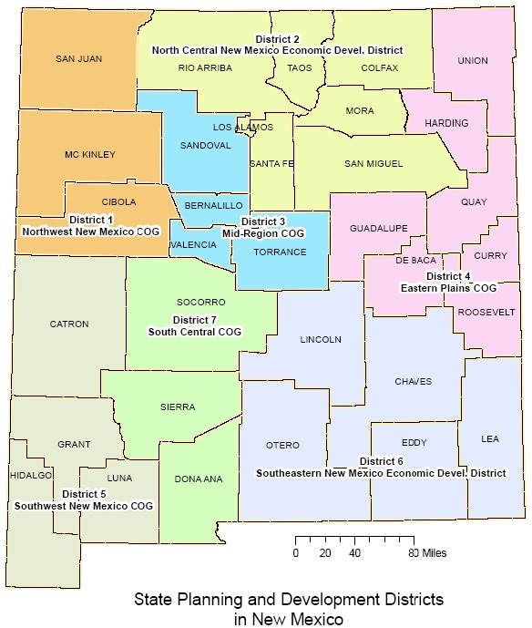
PDF brochure with state map at New Mexico Association of Regional Councils
http://swnmcog.org/links/newmarc.html
Regional Planning Districts/Councils of Governments
1 Northwest New Mexico Council of Governments
2 North Central NM Economic Development District
3 Mid Region Council of Governments
4 Eastern Plains Council of Governments
5 Southwest Council of Governments
6 Southeastern NM Economic Development District
7 South Central Council of Governments
Links to regions
46. Arizona
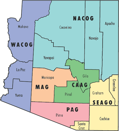
Central Arizona Association of Governments (CAAG)
Maricopa Association of Governments (MAG)
Northern Arizona Council of Governments (NACOG)
Pima Association of Governments (PAG)
South Eastern Arizona Governments Organization (SEAGO)
Western Arizona Council of Governments (WACOG)
Map and Links
http://www.azmag.gov/archive/AZ-COGs/index.asp
9. Pacific Division – West Region
47. Alaska
Map and links to regions: http://www.dec.state.ak.us/SPAR/perp/permits_new/other_ancla.htm

1. Anchorage Economic Development Corporation
2. Bering Strait Development Council
3. Copper Valley Development Association
4. Fairbanks North Star Borough Economic Development Commission
5. Interior Rivers Resource Conservation & Development Council
6. Kenai Peninsula Economic Development District
7. Lower Kuskokwim Economic Development Council
8. Mat-Su Resource Conservation & Development, Inc.
9. Northwest Arctic Borough Economic Development Commission
10. Prince William Sound Economic Development District
11. Southeast Conference
12. Southwest Alaska Municipal Conference
Map and links to regions: http://www.commerce.state.ak.us/ded/dev/ardor/ardor.htm
48. Washington
![]()
Map & links to regions
http://www.wsdot.wa.gov/planning/Regional/
49. Oregon

Map and links to regions
http://www.oedd.org/members.htm
Cascades West Economic Development District
CCD Business Development Corporation
Central Oregon Intergovernmental Council
Columbia-Pacific Economic Development District
Greater Eastern Oregon Development Corporation
Mid-Columbia Economic Development District
Mid-Willamette Valley Council of Governments
South Central Oregon Economic Development District
Northeast Oregon Economic Development District
South Oregon Regional Economic Development, Inc.
Portland Regional Partners/Portland-Vancouver Economic Development District
50. California
![]()
Map of California MPOs and RTPAs PDF
http://www.dot.ca.gov/hq/tpp/offices/orip/list/agencies.html
Directory of California's Councils of Government (COGs) online
http://www.calpin.ca.gov/directory/cog.php

Map p. 48 – “California Planners' 2011 Book of Lists” – PDF
http://www.opr.ca.gov/index.php?a=planning/publications.html#pubs-C
California Association of Councils of Governments - CALCOG
http://www.calcog.org/members/members.html
51. Hawaii

Counties Map - Census
http://quickfacts.census.gov/qfd/maps/hawaii_map.html
County Links
http://hawaii.gov/dbedt/info/economic/library/county-info
What a U.S. map of Sub-State Regions might look like. This is an old graphic that was not GIS generated.

The maps and links are from my paper: "The Sub-State District/Regional Council as a Geospatial Unit of Analytical Geography for the United States" presented March 25, 2011 at the Southern Regional Science Association (SRSA) Annual Meeting, New Orleans, Louisiana
The work builds on my paper: "Global Region-builder Geo-Code Prototype" presented at Regional Studies Association, Pécs, Hungary, May 25, 2010 and 57th Annual North American meetings of the Regional Science Association International Denver, Colorado,
November 13, 2010
The PowerPoints for these presentations are at: www.slideshare.net/regional
For a copy of either or both papers send an email to: Tom.Christoffel@gmail.com


No comments:
Post a Comment