by Census Regions and Divisions
States and their counties or equivalents are the two major political geographies in the United States. National and State data is collected for these boundaries. When it comes to regional analysis, the states are too large and the counties too small. Metropolitan statistical areas reflect major regional economic relationships, but that focus leaves out the non-metro counties. A longitudinal analysis for MSAs over decades is not fruitful, since the underlying composition changes.
A geospatial unit of analysis that is used in many states and could be used nation-wide is the sub-state district, generically known as the regional council. A majority of states have a complete system where the regional council is organized and may be a political subdivision. Long term analysis can be done for these State standard regions. The analyses can be used by these regions for programmatic purposes, such as economic development. Data solutions exist for States with an incomplete system or no system.
Following, by state, in relative geographic order based on Census Regions and Divisions, are maps of regional council regions, the names of regions and a means to get the map and check the organization via a link. Due to the image source and limits of web images, the scale varies. This is part of the ongoing work of the Regions Work Initiative begun in 1998 to prove this was possible. The Census map is first.

1. New England Division - Northeast Region
01. Maine

http://www.maine.gov/spo/landuse/techassist/regionalcouncillist.htm#map
02. New Hampshire
Regional Planning Commissions

http://www.strafford.org/rpclinks.htm
1 - North County Council
2 - Lakes Region Planning Commission
3 - Upper Valley Lake Sunapee Regional Planning Commission
4 - Southwest Region Planning Commission
5a - Central New Hampshire Regional Planning Commission
5b - Southern New Hampshire Planning Commission
5c - Nashua Regional Planning Commission
6 - Rockingham Planning Commission
7 - Strafford Regional Planning Commission
03. Vermont

http://www.vapda.org/index.html
04. Massachusetts

http://www.pvpc.org/resource_center/affiliate-agencies.shtml
05. Rhode Island
Counties as regions

http://www.dlt.ri.gov/lmi/maps/county.htm
06. Connecticut

OPM Map includes Stafford in the Capital region though it is a non-member.
http://www.ct.gov/opm/cwp/view.asp?a=2986&q=390892
2. Middle Atlantic Division - Northeast Region
07. New York

08. New Jersey

http://www.state.nj.us/dep/parksandforests/parks/maps/index.html

http://www.newjerseyvisitorsnetwork.com/regions/
09. Pennsylvania

http://www.ncentral.com/index.php?page=luted
Northwest Pennsylvania Regional Planning & Development Commission
Southwestern Pennsylvania Commission
North Central Pennsylvania Regional Planning and Development Commission
Southern Alleghenies Planning & Development Commission
Central: SEDA Council of Governments
Northern Tier Regional Planning & Development Commission
Central Region – no commission
Lehigh Valley Planning Commission
Northeastern Pennsylvania Alliance
Southeast: Delaware Valley Regional Planning Commission
3. South Atlantic Division - Northeast Region
10. Delaware

Counties as regions
http://dedo.delaware.gov/information/demographic_data/community_profile.shtml
11. Maryland

Regional Planning Councils listing at MDOT
1 - Tri-County Council for Western Maryland
2 – Suburban Maryland - Metropolitan Washington Council of Governments
3 - Tri-County Council for Southern Maryland
4 - Baltimore Metropolitan Council
5 - Upper Shore Regional Council
6 - Mid-Shore Regional Council
7 - Tri-County Council for the Lower Eastern Shore of Maryland
http://www.mdot.maryland.gov/Planning/Resources.html
12. District of Columbia

Metropolitan Washington Council of Governments
http://www.mwcog.org/about/jurisdiction/
13. Virginia

01 - LENOWISCO PDC
02 - Cumberland Plateau PDC
03 - Mount Rogers PDC
04 - New River Valley PDC
05 - Roanoke Valley-Alleghany RC
06 - Central Shenandoah PDC
07 - Northern Shenandoah Valley RC (formerly Lord Fairfax)
08 - Northern Virginia RC
09 - Rappahannock-Rapidan RC
10 - Thomas Jefferson PDC
11 - Region 2000 LGC (Formerly Central Virginia)
12 - West Piedmont PDC
13 - Southside PDC
14 - Commonwealth PDC (Formerly Piedmont)
15 - Richmond Regional PDC
16 - George Washington RC (Formerly RADCO)
17 - Northern Neck PDC
18 - Middle Peninsula PDC
19 - Crater PDC
22 - Accomack-Northampton PDC
23 - Hampton Roads PDC (combination of 20 Peninsula and 21 Southeastern Virginia)
http://www.vapdc.org/aboutpdcs.htm
14. West Virginia

Online map
1 - Region I Planning & Development Council
2 - Region II Planning & Development Council
3 - Regional Intergovernmental Council
4 - Region IV Planning & Development Council
5 - Mid-Ohio Valley Regional Council
6 - Region VI Planning & Development Council
7 - Region VII Planning & Development Council
8 - Region 8 Planning & Development Council
9 - Eastern Panhandle Regional Planning and Development Council-Region 9
10 - Belomar Regional Council - Region X
11 - Brooke Hancock Jefferson Metropolitan Planning Commission/Region Planning & Development Council
http://www.regionvi.com/regionalcouncils.cfm
15. North Carolina

A: Southwestern Commission
B: Land-of-Sky Regional Council
C: Isothermal Planning and Development Commission
D: High Country Council of
E: Western Piedmont Council of Governments
F: Centralina Council of Governments
G: Piedmont Triad Council of Governments
H: has been merged into other regions
I: Northwest Piedmont Council of Governments
J: Triangle J Council of Governments
K: Kerr-Tar Regional Council of Governments
L: Upper Coastal Plain Council of Governments
M: Mid-Carolina Council of Governments
N: Lumber River Council of Governments
O: Cape Fear Council of Governments
P: Eastern Carolina Council of Governments
Q: Mid-East Commission
R: Albemarle Commission
North Carolina's Regional Councils Association
http://www.ncregions.org/regcouncils.htm
16. South Carolina

http://www.centralmidlands.org/sccogs.asp
17. Georgia

Georgia Association of Regional Commissions
http://garc.ga.gov/main.php?Regional-Commissions-2
18. Florida

Florida Regional Councils Association
http://www.ncfrpc.org/state.html
4. East South Central Division - South Region
19. Kentucky

01 Purchase Area Development District
02 Pennyrile Area Development District
03 Green River Area Development District
04 Barren River Area Development District
05 Lincoln Trail Area Development District
06 Kentuckiana Regional Planning and Development Agency
07 Northern Kentucky Area Devlopment District
08 Buffalo Trace Area Development District
09 Gateway Area Development District
10 FIVCO Area Development District
11 Big Sandy Area Development District
12 Kentucky River Area Development District
13 Cumberland Valley Area Development District
14 Lake Cumberland Area Development District
15 Bluegrass Area Development District
http://www.kcadd.org/District_Contacts.html
20. Tennessee

MAAG Memphis Area Association of Governments
NWTDD Northwest Tennessee Development District
SWTDD Southwest Tennessee Development District
SCTDD South Central Tennessee Development District
GNRC Greater Nashville Regional Council
UCDD Upper Cumberland Development District
SETDD Southeast Tennessee Development District
ETDD East Tennessee Development District
FTDD First Tennessee Development District
http://www.discoveret.org/etdd/tdda.htm
21. Alabama

Alabama Association of Regional Councils
1 Northwest Alabama Council of Local Governments
2 West Alabama Regional Commission
3 Regional Planning Commission of Greater Birmingham
4 East Alabama - Regional Planning & Development Commission
5 South Central Alabama Development Commission
6 Alabama-Tombigbee Regional Commission
7 Southeast Alabama RP & DC
8 South Alabama Regional Planning Commission
9 Central Alabama Regional Planning and Development Commission
10 Lee-Russell Council of Governments
11 North Central Alabama Regional Council of Governments
12 Top of Alabama Regional Council of Governments
22. Mississippi
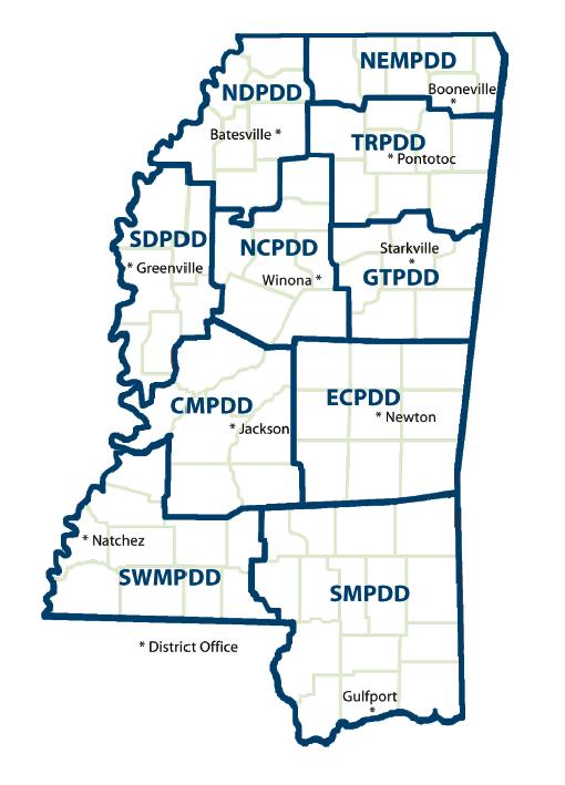
NDPDD North Delta Planning and Development District - 1
SDPDD South Delta Planning and Development District - 2
NEMPDD Northeast Mississippi Planning and Development District - 3
TRPDD Three Rivers Planning and Development District - 4
GTPDD Golden Triangle Planning and Development District - 5
NCPDD North Central Planning and Development District - 6
CMPDD Central Mississippi Planning and Development District - 7
ECPDD East Central Planning and Development District - 8
SMPDD Southern Mississippi Planning and Development District - 9
SWMPDD Southwest Mississippi Planning and Development District – 10
Mississippi Association of Planning and Development Districts (MAPDD)
Map of Districts and information in Directory and PowerPoint PDFs at site.
http://www.cmpdd.org/mapdd.php
5. West South Central Division - South Region
23. Louisiana

Map and links at Louisiana.gov
http://wwwprd.doa.louisiana.gov/census/plandist.htm
1 PDC Regional Planning Commission
2 CRPC Capital Region Planning & Development Commission
3 SCPDC South Central Planning & Development Commission
4 ARDD Acadiana Regional Development District
5 IMCAL Imperial Calcasieu Regional Planning & Development Commission
6 KDRP Kisatchie Delta Regional Planning & Development District, Inc.
7 CDC The Coordinating & Development Corporation
8 NDRP North Delta Regional Planning & Development District
Louisiana Association of Planning and Development Districts
http://www.lapdd.org/index.php
24. Arkansas

http://www.aiea.ualr.edu/research/pdd/default.html
Arkansas Planning and Development Districts
Central PDD
East PDD
Northwest EDD
Southeast EDD
Southwest PDD
West Central PDD
Western PDD
White River PDD
25. Oklahoma

Map from Department of Human Services
1 Grand Gateway Economic Development Association - GGEDA
2 Eastern Oklahoma Economic Development District - EODD
3 Kiamichi Economic Development District - KEDDO
4 Southern Oklahoma Development Association - SODA
5 Central Oklahoma Economic Development District - COEDD
6 Indian Nations Council of Governments – INCOG – Tulsa
7 Northern Oklahoma Development Association - NODA
8 Association of Central Oklahoma Governments - ACOG
9 Association of South Central Oklahoma Governments – ASCOG
10 South Western Oklahoma Development Authority - SWODA
11 Oklahoma Economic Development Association - OEDA
Oklahoma Association of Regional Councils
26. Texas

Region Name Number Abbreviation
Alamo Area Council of Governments 18 AACOG
Ark-Tex Council of Governments 5 ARK-TEX
Brazos Valley Council of Governments 13 BVCOG
Capital Area Council of Governments 12 CAPCOG
Central Texas Council of Governments 23 CTCOG
Coastal Bend Council of Governments 20 CBCOG
Concho Valley Council of Governments 10 CVCOG
Deep East Texas Council of Governments 14 DETCOG
East Texas Council of Governments 6 ETCOG
Golden Crescent Regional Planning Commission 17 GCRPC
Heart of Texas Council of Governments 11 HOTCOG
Houston-Galveston Area Council 16 H-GAC
Lower Rio Grande Valley Development Council 21 LRGVDC
Middle Rio Grande Development Council 24 MRGDC
Nortex Regional Planning Commission 3 NORTEX
North Central Texas Council of Governments 4 NCTCOG
Panhandle Regional Planning Commission 1 PRPC
Permian Basin Regional Planning Commission 9 PBRPC
Rio Grande Council of Governments 8 RGCOG
South East Texas Regional Planning Commission 15 SETRPC
South Plains Association of Governments 2 SPAG
South Texas Development Council 19 STDC
Texoma Council of Governments 22 TEXOMA
West Central Texas Council of Governments 7 WCTCOG
Texas Association of Regional Councils
http://www.txregionalcouncil.org/display.php?page=regions_map.php
Balance of States are in Part 2 due to graphic limits of Blogger posts.
State Geo-Codes Table
| Division | Geo-code | Region/State linked to region map page | Abr. | State FIPS |
| 1. New England Division |
| Northeast Region |
|
|
|
| 1 | Maine | ME | 23 |
|
| 2 | New Hampshire | NH | 33 |
|
| 3 | Vermont | VT | 50 |
|
| 4 | Massachusetts | MA | 25 |
|
| 5 | Rhode Island | RI | 44 |
|
| 6 | Connecticut | CT | 9 |
| 2. Middle Atlantic Division |
| Northeast Region |
|
|
|
| 7 | New York | NY | 36 |
|
| 8 | New Jersey | NJ | 34 |
|
| 9 | Pennsylvania | PA | 42 |
| 3. South Atlantic Division |
| South Region |
|
|
|
| 10 | Delaware | DE | 10 |
|
| 11 | Maryland | MD | 24 |
|
| 12 | District of Columbia | DC | 11 |
|
| 13 | Virginia | VA | 51 |
|
| 14 | West Virginia | WV | 54 |
|
| 15 | North Carolina | NC | 37 |
|
| 16 | South Carolina | SC | 45 |
|
| 17 | Georgia | GA | 13 |
|
| 18 | Florida | FL | 12 |
| 4. East South Central Division |
| South Region |
|
|
|
| 19 | Kentucky | KY | 21 |
|
| 20 | Tennessee | TN | 47 |
|
| 21 | Alabama | AL | 1 |
|
| 22 | Mississippi | MS | 28 |
| 5. West South Central Division |
| South Region |
|
|
|
| 23 | Louisiana | LA | 22 |
|
| 24 | Arkansas | AR | 5 |
|
| 25 | Oklahoma | OK | 40 |
|
| 26 | Texas | TX | 48 |
| 6. East North Central Division |
| Midwest Region |
|
|
|
| 27 | Michigan | MI | 26 |
|
| 28 | Ohio | OH | 39 |
|
| 29 | Indiana | IN | 18 |
|
| 30 | Illinois | IL | 17 |
|
| 31 | Wisconsin | WI | 55 |
| 7. West North Central Division |
| Midwest Region |
|
|
|
| 32 | Minnesota | MN | 27 |
|
| 33 | North Dakota | ND | 38 |
|
| 34 | South Dakota | SD | 46 |
|
| 35 | Iowa | IA | 19 |
|
| 36 | Nebraska | NE | 31 |
|
| 37 | Missouri | MO | 29 |
|
| 38 | Kansas | KS | 20 |
| 8. Mountain Division |
| West Region |
|
|
|
| 39 | Montana | MT | 30 |
|
| 40 | Wyoming | WY | 56 |
|
| 41 | Idaho | ID | 16 |
|
| 42 | Nevada | NV | 32 |
|
| 43 | Utah | UT | 49 |
|
| 44 | Colorado | CO | 8 |
|
| 45 | New Mexico | NM | 35 |
|
| 46 | Arizona | AZ | 4 |
| 9. Pacific Division |
| West Region |
|
|
|
| 47 | Alaska | AK | 2 |
|
| 48 | Washington | WA | 53 |
|
| 49 | Oregon | OR | 41 |
|
| 50 | California | CA | 6 |
|
| 51 | Hawaii | HI | 15 |


No comments:
Post a Comment